In Springfield – and in cities across the country – government policies keep racial segregation in place
RACE | Daniel C. Vock, J. Brian Charles and Mike Maciag. GOVERNING magazine
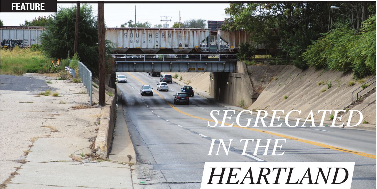
It didn’t take Silas Johnson long after he moved to Springfield to identify the border that separates the black section of the city from the white one.
Growing up in Mississippi as the civil rights movement swept through the South, Johnson knew about dividing lines. In the town of Macon, blacks knew to stay on their side of the railroad tracks. “It wasn’t something that was taught,” he says. “It was just something that was known.”
After he graduated high school in 1973, Johnson left the South to join his brother in Springfield, the state capital and former home of Abraham Lincoln. But Johnson soon discovered that race relations in his new home weren’t much better than what he’d left behind. Blacks and whites attended separate schools. Blacks were excluded from certain professions.
And just like Macon, Springfield cleaved in two along racial lines, with railroad tracks again marking the split. This time, it was the Norfolk Southern tracks alongside Ninth Street. East of the tracks, the neighborhoods were predominantly black, and many blocks were pockmarked by vacant houses and boarded-up businesses. West of the tracks, the neighborhoods got progressively whiter and wealthier. “I experienced a lot of racism here. It was more covered up than it was open,” says Johnson, now 63, pastor of Calvary Missionary Baptist Church and president of the nonprofit Faith Coalition for the Common Good. “In the South, blacks stayed in certain areas and so did whites. That’s the same here now in Springfield.”
That pattern persists in cities throughout the state. In fact, according to a new Governing investigation, segregation between blacks and whites is worse in most of Illinois’ metropolitan areas than in demographically similar areas around the country. It’s particularly bad in large metro areas, and certainly the Chicago region is the most segregated in Illinois. But the state’s smaller cities are also disproportionately segregated.
Springfield may have launched the political careers of Lincoln and Barack Obama, but it is among the worst third of American cities in terms of black-white segregation, according to our analysis of federal data. Both the Springfield and Champaign-Urbana metro areas are more segregated than that of Charlottesville, Virginia, or the Daphne-Fairhope-Foley area near Mobile, Alabama, even though they all have similar populations and percentages of black residents. The truth is that segregation isn’t limited to the South, or to large cities. America’s racial divide, in fact, runs right through the Heartland.
Governing conducted a six-month investigation into segregation in downstate Illinois, and why and how it has persisted there. We spoke with more than 80 people, including mayors and other city officials, legislators, sociologists, attorneys, school district officials, historians, community activists, housing experts and both black and white residents. We analyzed 50 years’ worth of U.S. Census data for economic and demographic trends,
along with both state and federal school enrollment data. We also drew
from hundreds of pages of court documents, information obtained through
Freedom of Information Act requests, several books and dozens of
academic reports. This is an abridged version of the first article in
the series. The complete article is available at illinoistimes.com.

What
emerged was a picture of the way segregation continues to shape and
reshape metropolitan areas in Illinois and, indeed, throughout many
parts of the country. In these cities, segregation means not just a
physical divide, but a huge disparity in resources. White areas of town
benefit from more development, better infrastructure and more
accommodating government policies.
What’s
more, we found local governments bear much of the responsibility for
creating and maintaining segregated communities. Mayors and other city
officials are often focused on immediate concerns, such as balancing
tight budgets or attracting economic development. While those are
legitimate, pressing issues, the resulting policies can often reinforce
segregation. Through unspoken traditions and ingrained attitudes, as
well as explicit government actions, city officials are in many ways
responsible for maintaining a system that still divides whites and
blacks.
When it comes
to land use – what gets built where – governments use zoning
restrictions to keep out rental housing, which attracts blacks and other
minorities, from predominantly white areas. They approve new
residential subdivisions with strict deed restrictions that make large
swaths of communities unaffordable to lowincome residents and often
explicitly bar any use other than single-family homes. As they restrict
where apartments can be built, local governments also play a big role in
deciding where public housing and other taxpayer-supported affordable
housing projects are located. That often leads to concentrated areas of
low-income housing in black neighborhoods. Those changes almost
inevitably become permanent, because the income restrictions and other
rules that come with public subsidies last for decades.
Public schools are a key factor as well.
While
segregation in schools is often viewed as a product of the
neighborhoods the schools are located in, the truth is much more
complicated because schools shape the neighborhoods they serve. In many
cases, in fact, they exacerbate segregation by driving white flight to
suburban areas. That is especially true in Illinois, because of its
proliferation of small school districts. As cities such as Peoria and
Springfield stretch beyond their original district borders, white
residents flock to the suburban-style schools on their peripheries.
Farther-out villages have transformed themselves from farm towns to
bedroom communities by luring white families with new subdivisions and
the promise of better schools in stand-alone school districts. The
result is that predominantly white suburban districts are flourishing,
while urban districts have become increasingly black and suffer from
declining tax bases.
Finally,
residents in predominantly black neighborhoods routinely face more
scrutiny from police and other government agencies, which reinforces the
patterns of segregation that have already emerged. Government actions
such as increased code enforcement, zero tolerance policies for drugs in
public housing and disproportionately targeting black
neighborhoods for traffic stops result in black residents facing more
municipal fines or other minor punishments.
Wrong side of the tracks
While
people may associate segregation with the Jim Crow-era South, the truth
is that the most segregated metropolitan areas today, in terms of where
people live, are in the industrial Midwest and the Northeast, the
destinations for most blacks fleeing the South during the Great
Migration of the 1900s. The cities of those regions established housing
patterns that persist today, especially where economic troubles have
made new growth and investment difficult.
Nationally,
overall levels of segregation have fallen in recent decades. That’s
especially true in cities and other small geographic areas, like suburbs
or school districts. Blacks and whites are slightly more likely to live
in the same neighborhoods than they were in the 1980s.
But
that’s not the whole story. A more troubling pattern emerges when you
widen the scope to look at entire metropolitan areas, focusing not just
on individual cities or suburbs but looking at cities and their suburbs
together. Instead of moving to different areas of the same city, whites
are moving farther away to suburbs and exurbs. That’s why, measured at
the metro level, progress toward more racially integrated neighborhoods
over the past few decades looks decidedly less impressive. In fact, in
the metro areas for Peoria, Danville and Champaign-Urbana, the degree of
segregation remains roughly as high as it was in 1980. It’s that metro
area measure by which the Peoria area ranks as the sixth most segregated
in the nation.
Sociologists
commonly measure segregation by calculating what’s known as a
dissimilarity index. That shows what percentage of, for example, whites
would have to move to black neighborhoods for them to live in a
neighborhood that would have the same black-white ratio as the area as a
whole. Governing calculated that measure to show the degree of segregation both in metro areas and in their schools.
Illinois
has several other highly segregated metropolitan areas. Danville, a
small city near the Indiana border, is the 12th most segregated place in
America with at least 10,000 black residents. Along with Springfield,
Kankakee and Rockford are among the worst third. (The Governing analysis
was confined to segregation between blacks and whites, because the
number of Hispanics and Asians living in most downstate Illinois cities
is relatively small.)
Perhaps
no Illinois city displays its segregation more plainly than the capital
of Springfield itself. “You see it when you cross that invisible
dividing line,” says Teresa Haley, the president of both the Springfield
branch and the state chapter of the National Association for the
Advancement of Colored People (NAACP).
One
way to see it clearly is to drive along South Grand Avenue, a major
east-west thor oughfare that cuts across the city. Starting on the east
side, you’ll find Springfield’s poorest – and most heavily black –
neighborhoods. Some blocks contain tidy, modest houses, but many are
ramshackle. The streets are poorly lit, and they often lack curbs,
sidewalks and gutters. In three east side neighborhoods, about half the
households live in poverty, according to the most recent data. The
unemployment rate across those three neighborhoods is 24 percent. Life
expectancy in two of the neighborhoods is 70 years old or below,
compared with nearly 79 years nationally. Overall, the five-census-tract
area covering the east side is 65 percent black, but in some
neighborhoods it’s as high as 80 percent.
Drive
west on South Grand, under the viaduct carrying the Norfolk Southern
tracks, and things immediately begin to change. On the largely white
west side, just a mile and a half away, South Grand is covered by a
canopy of trees as it makes its way past blocks of stately brick houses,
many of them mansions on enormous lots. The street itself narrows and
then disappears completely into Washington Park, 150 acres of rustling
trees and rolling hills graced with a carillon, a rose garden, fishing
ponds and a popular running path. Two golf courses adjoin the park. Also
nearby is Leland Grove, a village of 1,500 people surrounded by
Springfield. It’s an enclave within an enclave, where the median
household income is double that of the rest of the city. According to
the Census Bureau, the population of Leland Grove is 95 percent white
and 1 percent black.
Beyond
that, Springfield keeps sprawling west. Residents in new subdivisions
can see combines and grain elevators from their driveways. Commercial
development has been in hot pursuit: Restaurants, dentists, banks, hair
salons and a Walmart have opened up, not to mention the churches,
schools and parks that inevitably follow wherever people move. “With
Springfield,” says Mayor Jim Langfelder, a banker by trade, “everybody
wants to go west. They want to go where the numbers are, where the
incomes are. With the east side, though, it’s a struggle. You have
pockets of development, but there’s still a lot more to go.”
Of
course, many of the symbolic racial borders in Springfield and other
cities have been codified in official ways, with real-world
consequences. Perhaps the best-known examples of that are the
“redlining” maps first drawn by the federal government during the Great
Depression. As part of the New Deal, Congress introduced new federally
backed mortgages that were intended to make home loans more affordable
for middle-class families for the first time. To keep from losing money
on the loans, the federal government hired real estate agents in 239
cities to draw maps designating where the most “creditworthy” residents
lived. Areas deemed high-risk were outlined in red. As a rule, the
agents drew bright
red lines around any minority neighborhoods. Thus, whites were able to
buy new homes, build wealth and pass along that wealth to their
families. Blacks could not get credit to even maintain or improve their
existing properties. Their neighborhoods suffered as banks and
businesses fled, buildings deteriorated and outside landlords scooped up
the distressed properties so they could rent them out. Those policies
have had a long-lasting effect at the individual level as well. To this
day, 62 percent of black households in Illinois rent their homes,
compared with 27 percent for whites. The 1968 Fair Housing Act and
subsequent federal laws ended legally sanctioned redlining, but the
patterns from those maps persist today.
White flight continues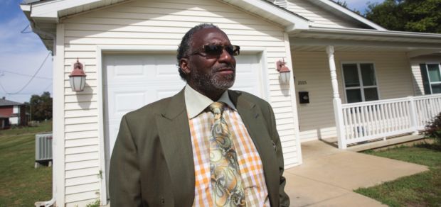
Increasingly,
the disparities caused by racial segregation aren’t within local
jurisdictions but between them. Just look at downstate Illinois schools.
The core urban school districts in Bloomington, Champaign, Urbana,
Springfield and Decatur – all still predominantly white cities – had
majorities of white students in the 2002-2003 school year. Now, none of
them do. Over the same period, the share of white students in Rockford
Public Schools also dropped, from 48 percent to 30.
Urban
districts are losing white students far faster than their metropolitan
areas at large. Decatur Public Schools, for example, lost 38 percent of
its white students in the last 15 years, but the rest of the metro area
only lost 7 percent of its white students. By comparison, the district
lost just 11 percent of its black students in the same time frame.
Peoria
provides the starkest example. The main school district there has fewer
than half of the white students it had 15 years ago, but the decline in
white students for all of the other school districts in the metro area
was less than 8 percent.
In
other words, white flight to suburban areas is drastically altering the
makeup even of small metropolitan areas in Illinois. Once-sleepy farm
towns are now attracting residents by the hundreds. In a bid that’s
familiar to suburbanites in bigger metro areas, these hamlets market
themselves as both conveniently close to the job centers in nearby
cities and as distinct from them. “With excellent schools, a low crime
rate and beautiful natural parks, Roscoe is the perfect place for your
business, family and home,” crows the website of Roscoe, a village of
10,500 people north of Rockford that’s close to the Wisconsin border.
From 1990 to 2010, the white population there tripled from 2,326 people
to 9,544.
Meanwhile,
the number of black people in the village grew from 13 in 1990 to 325 in
2010. Chatham, a village just south of Springfield, touts the motto
“Family, Community, Prosperity.” It saw its white population grow by
4,356 people over those two decades, while it added 265 black residents.
The
outflow is having a major impact on core cities. Since 1970, the cities
of Decatur, Peoria and Rockford lost between 25 and 40 percent of their
white residents, while surrounding jurisdictions within the same
regions collectively added white residents. At the same time, black
residents are moving into older, traditionally white neighborhoods in
many of those cities. In three neighborhoods just north of downtown
Peoria, for example, a total of more than 3,400 white residents have
moved out since 2000, while the number of black residents increased by
nearly 2,000.
The
popularity of the farther-out enclaves puts big-city leaders in a bind:
They can either compete with the suburbs by annexing new subdivisions
and strip malls carved out of farmland, or they can lose that tax base
to nearby suburbs that are only too happy to take it off a city’s hands.
Meanwhile,
local governments in predominantly white areas have made it difficult
for many blacks to move to the areas of new development. Very few of the
predominantly white suburbs that have sprung up in recent decades allow
for apartment-style multifamily units to be built within their borders.
The lack of rental choices disproportionately affects black residents,
because, again, they are more than twice as likely to rent their home as
whites. The housing stock determines where they can live.
One neighborhood at a time
Bringing
affordable housing to Springfield’s east side is exactly what Silas
Johnson is trying to do, and he’s already made a lot of progress.
Johnson made a good living as an electrician.
He
went to work for the city, and eventually saved up enough money to buy a
house. But in 1984, when he was 29, Johnson took on another job, too,
as pastor of Calvary Missionary Baptist Church on the far east side. He
saw firsthand what decades of disinvestment had done to the immediate
neighborhood around the church. Clutter and tall weeds filled vacant
lots. People were dealing drugs across the street, and the houses next
door were rundown eyesores.
He
knew he needed to act. “In order to control your neighborhood, your
area, you need to own stuff around you,” he says. “You can’t wait on
everybody else.”
The
church started acquiring property, so it could have the trees trimmed,
the grass cut and the drug-dealing eliminated. Johnson also created a
nonprofit to buy rundown houses from absentee landlords, fix them up and
sell them to neighborhood residents at a low price.
The
nonprofit’s original plan had some serious weaknesses. One reason why
people hadn’t already been buying homes on the east side is because they
couldn’t get a loan from the bank. Either their credit wasn’t good
enough, or the banks didn’t want to invest in an east side property. One
drawback to living in a predominantly black neighborhood is that
property doesn’t hold its value well there, because whites generally
don’t want to live there, lowering the property’s marketability. The
other reason was the homes themselves. Not only were they old, but,
because they were old, they tended to be small and crowded onto lots
just 40 feet wide. The city of Springfield started mandating that lots
be at least 60 feet wide in 1966, but the houses predated that
requirement.
So
Johnson worked with a developer to come up with a different approach.
The nonprofit, Nehemiah Expansion, would build its own single family
houses using the federal low-income housing tax credit. The tax credit
allows corporations and other big taxpayers to reduce their taxes by
funding affordable housing through credits bought from state agencies.
The states then distribute the money they raise to projects on a
competitive basis.
What
that means is that it costs Nehemiah substantially less to build new
housing. The nonprofit also borrows money at low interest rates from the
Illinois Housing Development Agency (IHDA), which it pays back using
the rent paid by occupants. And the city and other creditors agree to
remove the liens they hold against some of the vacant homes, sometimes
using the in-kind contribution as a tax write-off.
As
for the houses, Nehemiah looks for places it can buy three 40-foot-wide
lots next to each other and split them into two 60-foot-wide lots.
That’s enough to build one of five models of houses, with anywhere from
two bedrooms to four bedrooms, a laundry room and a one-car garage.
But
the real impact of the houses comes at the end of 15 years, when
they’re permitted to go on the market. The renter in the unit gets first
dibs, and he or she only has to pay what Nehemiah owes IHDA, but not
the cost covered by the tax credit. The theory is, in other words, that
occupants could buy a $70,000 house for $50,000.
That
would give the buyer instant equity, something that’s long been in
short supply in black neighborhoods, and signals to the market that
homes can sell on the east side.
Nehemiah
has built 80 new homes so far, with plans for more. The first batch of
20 homes will go on sale in about three years. Most of Nehemiah’s
renters are black, although several are white. “When we started this
project, [this area] was 75 percent rental, 25 percent owneroccupied
housing,” Johnson says. “My goal is to reverse that whole trend, to go
back to being 75, 80 percent owner-occupied.”
It’s
certainly an ambitious goal, considering just a third of people in
surrounding neighborhoods own their own homes. But it seems to be one
that’s paying off already. For several blocks on the east side of
Springfield, resources available to black residents such as quality
housing and perhaps even home equity seem to be slowly building, rather
than constantly draining as a result of racial segregation.
This is an edited excerpt from Governing’s four-part series on segregation in downstate Illinois. For a link to the full article, go to illinoistimes.com.
About the article
Governing
magazine, based in Washington, D.C., covers state and local government
across the country – the laws and leadership that shape the way states
and cities serve their citizens. The magazine decided to devote
attention to the ongoing issue of residential segregation in America,
and how government policies continue to reinforce the racial divide
between blacks and whites. Staff writer Daniel C. Vock, an Illinois
native and a former Statehouse reporter in Springfield, began looking at
the issue in several downstate Illinois cities. It’s easy to think of
segregation as something most prevalent in the South, or in large urban
areas. But parts of downstate Illinois are among the worst metro areas
in the nation for residential and school segregation. The focus on this
part of Middle America provided a lens on this crucial issue throughout
the country.
Vock,
along with Governing staff writer J. Brian Charles and data editor Mike
Maciag, spent six months investigating and reporting this special
series. Together with a photographer, the team spent a combined 20 days
reporting on the ground in Illinois, including six days altogether in
Springfield.
